


How 3D Design Tools Help Shape More Efficient Cities
Discover how 3D design tools improve urban planning, boost efficiency, and support sustainable city development in simple, clear steps.

In today's fast-changing world, cities are growing quickly. More people are moving into urban areas, and this brings both opportunities and challenges. As cities become more crowded, planners, architects, and engineers must find smarter ways to design them. This is where 3D design tools play a big role.
These tools are helping to create efficient, sustainable, and well-planned cities that work better for people, nature, and the economy. In this article, well explain how 3D design tools are changing city planning and why they are important for the future of urban living.
What Are 3D Design Tools?
3D design tools are software programs that allow professionals to create three-dimensional models of buildings, roads, parks, and other structures. These tools include programs like AutoCAD, Revit, SketchUp, Rhino, and BIM (Building Information Modeling) software.
Instead of drawing flat, 2D plans on paper, city planners can now build lifelike digital models that show how a city will look and function. These models help people see what will happen before any real construction begins.
Why Are 3D Design Tools Important for Cities?
Cities are complex. They include buildings, roads, bridges, parks, and public services like water and electricity. Planning all these parts correctly is a big task. Using 3D design tools makes this process easier and more accurate. Lets look at how these tools help create better cities.
1.Better Planning and Visualization
3D tools help planners and designers visualize city projects in a clear and realistic way. Instead of looking at flat blueprints, they can see a 3D view of streets, buildings, and open spaces.
This makes it easier to understand:
-
How tall buildings will look from the street
-
How much sunlight or shade a park will get
-
How new roads will affect traffic
With 3D models, it becomes much simpler to spot problems early and make smart decisions before construction starts.
2.Improving Transportation Systems
Efficient cities need smart transportation systems. 3D design tools help simulate:
-
Traffic flow
-
Public transport routes
-
Parking areas
-
Pedestrian walkways and bike lanes
By creating 3D maps of roads and transit systems, planners can test different designs and choose the best one. This saves time and money and reduces future problems like traffic jams or unsafe intersections.
3. Supporting Sustainable Urban Development
A big part of modern city planning is making cities more eco-friendly. 3D tools help with this by:
-
Measuring sunlight and wind patterns
-
Planning for green spaces
-
Predicting energy use in buildings
-
Reducing environmental impact
For example, planners can use 3D models to decide the best place for solar panels or how to design buildings that stay cool in summer without using too much air conditioning.
These tools also help with green architecture and sustainable urban design, which are very important in fighting climate change.
4.Helping with Public Engagement
Often, people have a hard time understanding city plans because they are full of technical drawings and complex terms. But 3D models are easy for everyone to understand.
They can:
-
Show virtual walkthroughs of future parks or buildings
-
Help communities give feedback
-
Make city meetings more interactive
This helps planners make decisions that fit the real needs of the community. When people can see how a new park or road will look, they can share their thoughts and feel more involved in the project.
5.Connecting with Smart City Technologies

Modern cities are becoming smart. This means they use technology, data, and sensors to manage everything from traffic lights to garbage collection. 3D design tools can connect with these systems to create digital twins of cities.
A digital twin is a live 3D model that shows whats happening in real-time. For example, it can:
-
Track traffic conditions
-
Show water or energy use
-
Predict when a bridge or road needs repair
This helps city officials make better choices and respond quickly to problems.
6.Saving Time and Money
3D design tools reduce mistakes. When everything is clear and visible in 3D before construction begins, there is less chance of costly errors. Projects move faster because:
-
Changes can be made quickly in the model
-
Different teams can collaborate better
-
Delays are avoided by solving problems early
This leads to cost-effective and faster urban development, which benefits both the government and the public.
7.Real-World Examples of 3D in Urban Planning
Many cities around the world are already using 3D tools to build smarter environments.
Singapore:
Singapore has created a full 3D model of the entire city. This model helps in everything from planning new buildings to managing emergencies.
Helsinki:
Helsinki, the capital of Finland, uses a 3D city model with real-time data. It helps in energy planning, transport, and even tourism.
New York:
New York City has used 3D zoning tools to manage building heights, public spaces, and neighborhood design.
These examples show how technology leads to better decision-making in real-world cities.
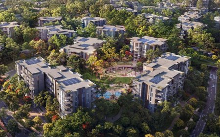
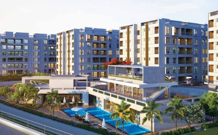
8.The Role of 3D Architectural Rendering
While 3D planning tools help create city layouts and infrastructure, 3D architectural rendering services play a big role in visualizing specific buildings and developments within a city. These services turn building plans into realistic images or animations.
They help:
-
Developers pitch their ideas to investors
-
Planners understand how a building fits into the city
-
Communities see how new buildings will look before they are built
You can learn more about professional 3D architectural rendering services and how they support urban development by showing high-quality visuals of planned buildings.
9.The Future of Urban Design with 3D Tools
As technology improves, 3D design tools are becoming smarter. Some future trends include:
-
Artificial Intelligence (AI) to suggest better city layouts
-
Cloud-based design tools for easier teamwork
-
3D printing of building parts for faster construction
-
Augmented Reality (AR) for exploring projects in real space
These innovations will make cities more flexible, livable, and efficient for the people who live in them.
Final Thoughts
Building better cities is not easy. It requires planning, collaboration, and smart use of technology. 3D design tools are making this possible by helping experts create cities that are efficient, beautiful, and sustainable.
They support better decision-making, reduce waste, involve the public, and speed up development. Whether its managing traffic, building greener neighborhoods, or planning smart infrastructure, these tools are shaping the cities of the future.